Dynamical Downscaling and Regional Ocean Dynamics
Regional models are used to downscale large-scale information from global circulation models through physically consistent open boundary conditions. As part of my research, I have developed and used a variety of such high-resolution ocean models that allow for representation of processes on a wider range of spatial and temporal scales, including tides, and their interactions over a specific region of interest.
Novel Approaches to Model Validation
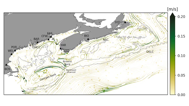
During my dissertation research, I developed novel approaches for ocean model validation and applied the validated models to test new interpretations of alongshore changes in mean dynamic topography (MDT), the height of the mean sea surface above the geoid. While it had been shown previously that geodetically referenced sea level observations at tide gauges and model predictions of MDT generally converge on global and basin scales, I showed that this also holds on smaller scales. The geodetic estimates of coastal MDT are limited to locations where decades of sea level observations exist. I developed a fundamentally different approach to evaluate model predictions of coastal MDT using observations of overtides that also helps optimize the configuration of ocean models, including their bathymetry. This new approach only requires short records of sea level and currents,thereby increasing the number of locations at which models can be assessed.
Coastal Mean Dynamic Topography
Mean dynamic topography (MDT) describes variations in the mean sea surface height above a reference surface called a geoid. By combining theory, idealized models, and a regional ocean circulation model, I showed that this alongshore tilt of MDT can be interpreted in two complementary, and dynamically consistent, ways: in the coastal view, the tilt of MDT along the coast can provide a direct estimate of the average alongshore current. In the regional view, the tilt provides a measure of area-integrated nearshore circulation. This highlights the value of using geodetic MDT estimates for model validation and ocean monitoring.
Downscaling Global Climate Simulations
Regional ocean models can be forced by global climate simulations to improve estimates of historical and future circulation and hydrography. As part of the Northwest Atlantic Biological Carbon Pump Project, I contributed to the development of a coupled circulation–ice–biogeochemistry modelling system, a joint effort by three interdisciplinary research groups at Dalhousie University including the groups of Eric Oliver, Jinyu Sheng, and Katja Fennel. During the model development, I took on the leading role in configuring the sea ice model and its coupling to the ocean component. I also developed a framework for correcting systematic biases before downscaling global climate simulations and future projections. This work showed that removing mean biases in the model forcing results in a more accurate simulation of the mean state, and additional variance correction only leads to minor further improvement.
Related Publications
Renkl, C., Oliver, E.C.J., Thompson, K.R. (2025). The alongshore tilt of mean dynamic topography and its implications for model validation and ocean monitoring. Ocean Science, 21(1), 181–198. https://doi.org/10.5194/os-21-181-2025. [EGU Highlight Paper].
Ohashi, K., Laurent A., Renkl, C., Sheng, J., Fennel, K., Oliver, E. (2024). DalROMS-NWA12 v1.0, a coupled circulation–ice–biogeochemistry modelling system for the northwest Atlantic Ocean: development and validation. Geoscientific Model Development, 17(23), 8697–8733. https://doi.org/10.5194/gmd-17-8697-2024.
Renkl, C., Thompson, K.R. (2022). Validation of Ocean Model Predictions of Mean Dynamic Topography in Shallow, Tidally Dominated Regions Using Observations of Overtides. Journal of Geophysical Research, 127(3), e2021JC018095. https://doi.org/10.1029/2021JC018095.